
Did you know ClaimControl integrates with Google maps ?
This means that more accurate location data can be collected, as no matter how you record data about an insurance claim or incident, (whether it be paper, spreadsheet, or a bespoke system), a critical piece of information that will always be captured is, where did it take place? Typically, this information gets recorded in the incident detail, shared with the insurance company and that’s the end of its usefulness, but our software can provide even more insight.
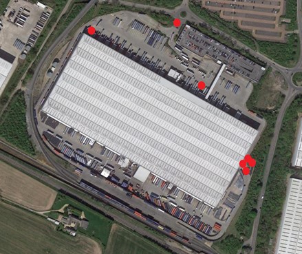
Here’s an example of why Google Map locations are so important?
When a claim or incident is recorded in ClaimControl the notifying party can ‘drop-a-pin’ to show exactly where the incident happened, and this can be done from a mobile device or laptop. This results in more accurate location data being collected, which is especially useful when a location doesn’t have a full postal address, as is often the case for a building site for instance. This accuracy can provide valuable insight and identify incident hot spots on large sites over many acres.
A great example of this comes from a conversation we had recently with a prospective customer operating many distribution centres. Traditional capture of location data would cover this site under one address, but our ability to utilise exact coordinates for the incident means that by using ClaimControl, they’d be able to generate an incident map like the one below. This can then highlight areas that are perhaps difficult to manoeuvre around, or where too many people operate at the same time. Thus providing valuable information to manage and mitigate the risk of incidents.
Google map integration can also help identify fraud.
The next part of our Google maps integration work, is being able to combine data. For example, like the above which shows where an incident has happened, further associated GPS data like videos or photos can be attached the the incident / claim record to further provide supporting evidence. So where an image or video has this data, ClaimControl can plot on the map where the incident took place as well as where the photo was taken. This can flag up anomalies and highlight possible fraud, for example, if the image provided alleges to be from the scene, but was actually taken 100 miles away.
Our commitment to continuous development has seen a further enhancement to this functionality, and we can now analyse time as well, which can flag if there are timing disparities between evidence and incident.
Read more about the features of our software products here.